If you are planning to deploy your own LPWA network then you’ll need to understand a few things about RF signal propagation, run a few models and then conduct a few tests in the real world. In this article, we are going to explore what is involved so fasten your seat belts and let’s go…
First off, remember the maxim, “keep it simple”. We are going to progress through a series of steps and it will quickly become obvious that it makes sense to approach these in sequence.
Step one – Line of sight
It seems obvious doesn’t it. If you cannot see the location of the end device from the location of the base station then the base station cannot ‘see’ the end device. Buildings that you cannot see with your eyes, because, for example, they are in a valley or behind a mountain, cannot be covered with a base station antenna, at least not reliably, from that height. This is the first stage of any physical network planning process and it is intuitive. The obvious way to maximise coverage is choose locations where you are able to see a large number of the places where your end devices will be located and this typically means that a base station will be mounted as high as possible. This much is obvious but it makes sense to take this first simple step in your network planning. What is stage two? Modelling…
Step two – Radio Propagation by Excel Sheet
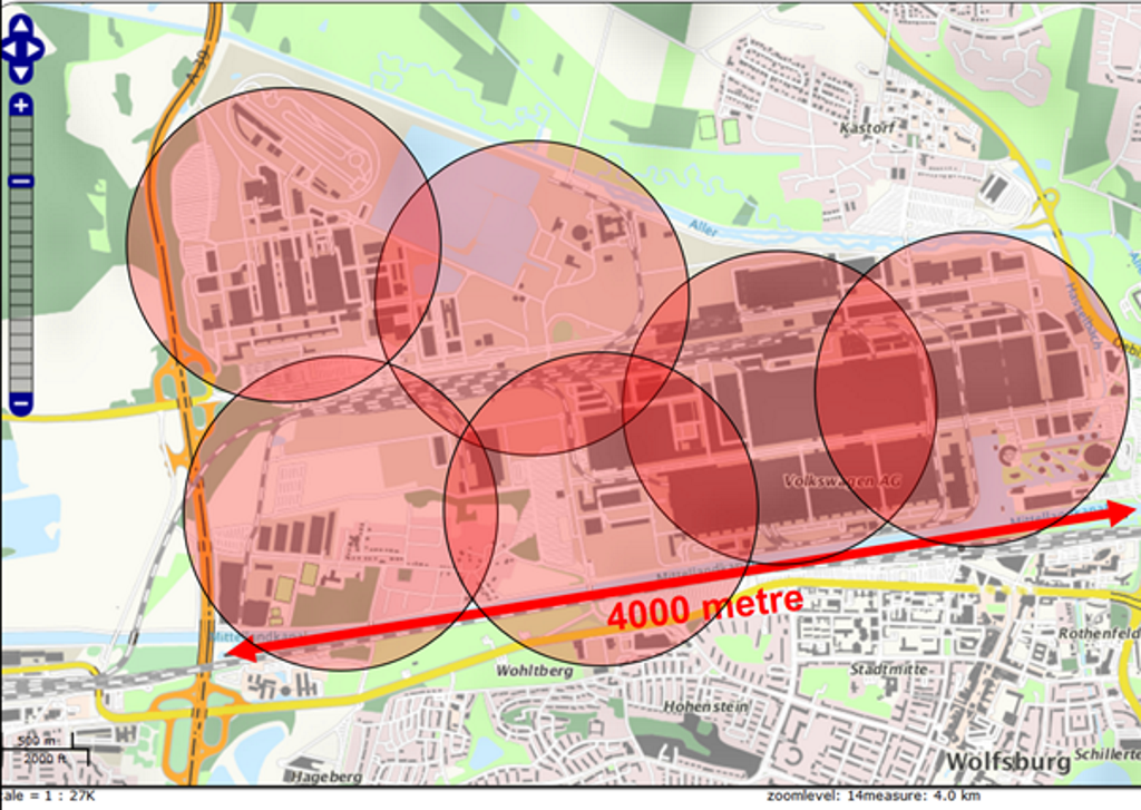
If you have a list of possible base station locations then you can use a radio propagation model to plan the possible coverage from each base station. In the basic step, you use an Excel Sheet and a common radio propagation formula to calculate an estimated coverage range. Each base station antenna coverage will be shown by a circle. The picture as below shows the planning of a LPWAN with six Weightless base stations at the factory plant of Volkswagen in Wolfsburg.
Step three – Radio Propagation with terrain software
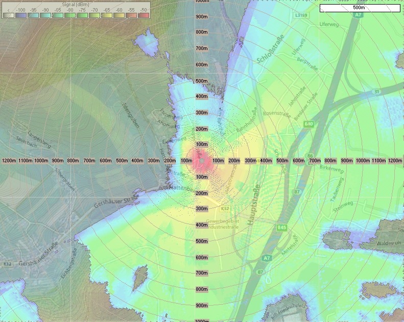
Using radio propagation software with terrain modelling and information about building density and land occupancy you can realistically begin to plan the LPWAN coverage of the area to be covered in more depth. Terrain models, including 2D building density and land occupancy are typically available in Europe are quite often public domain datasets and therefore free of charge. Even the radio propagation software to support the terrain data is often free of charge. However, to set up the terrain software and to use it is time consuming so, depending on your in-house competencies, you may need to contract a third party for some consulting on, or implementation of, signal propagation modelling software. Requests to harald.naumann (at) lte-modem.com are welcome. 🙂
You will now have a reasonably good idea where your base stations are going to go – which buildings they will be mounted onto and which masts you will need to build or lease from existing users/operators. You will be able to forecast, with some certainty, the coverage that you should be able to achieve with this network. Line of sight and software modelling are a great way to plan the initial architecture but there is no substitute for real world testing. That is stage four…
Step four – Live test
Place some LPWAN radio modules connected to the planned base station antennas on the towers or buildings in the locations that your initial planning has identified. You do not need a dedicated base station to do this, just get yourself an 868 MHz radio module working off a battery with a Raspberry PI or Arduino and some test firmware. It is more than enough.
A test node connected to some kind of GPS module and the Raspberry Pi or Arduino will suffice to make an accurate assessment of the RF characteristics at specific locations. Move systematically around the area that the network must service and record the signal strength on an SD card; you will quickly build up a map of realistic coverage.
A Keyhole Markup Language (KML) file enables geographical visualisation and annotation in both 2D and 3D was developed initially for work with Google. Convert the data that you captured in the field test to KML files and upload it to Google Earth or Google maps. The recorded tracks will show different colours to indicate different field strengths throughout the area your network is designed to cover.
Option – Radio propagation with terrain software and 3D data of the environment
Still not good enough? Well this is the poor man’s approach to real world test result visualisation but if you are blessed with a more expansive budget or need to have more confidence before a test network is deployed, commission a simulation built on a real 3D terrain propagation model. This will include the 3D data for the buildings over the area that you intend to deploy the network.
What is a Radio Propagation Model?
Radio Propagation Models sound complex and, well, they are. Nevertheless, they are based on well-respected and tested radio propagation theory backed up by real world empirical tests – in other words, they work. Whilst the physics that underpins the theses is complex, their use is less so and well within the capabilities of a good network-planning engineer. The gold standard in radio propagation is the Okumura-Hata model. If you want to know more about the theory and history then Wikipedia is your friend – start there for more detail.
In simple terms however, modelling seeks to use mathematical techniques to characterise the way in which radio waves propagate as a function of distance between transmitter and receiver in different types of environments in order to predict the way that they will behave in the real world. As rule of thumb radio waves in free space, or in a real world near equivalent to free space – a flat, featureless rural landscape with no trees, buildings, mountains or other physical obstacles – will behave more or less according to the inverse square rule. Introduce tall, brick, steel and cement based buildings, mountains and trees into the space between the transmitter and receiver and intuitively we already know that the RF signal is going to behave differently. Moreover, by differently we mean more poorly. But how much more? That is what the Okumura-Hata model seeks to do – quantify the effects of ‘obstacles’ between the base station and end device to determine overall signal path attenuation.
The models were validated extensively in real world tests carried out in Tokyo in 1968 and these tests hold true today – the Okumura-Hata model fits very well in Sub-GHz spectrum. There are three different types of environments for which different models are appropriate – urban, suburban and rural. The rural model, as we might imagine, is based on an environment with few trees and buildings, mostly low level. A suburban model included villages and towns with more houses and trees but again, mostly low level. If you have been to Tokyo you will know what an urban environment looks like. Actually, we all know what an urban environment looks like. It looks like a city.
There are limitations to the Okumura-Hata model that need to be considered.
The frequency of the radio signal needs to be somewhere in the range of 150 to 1500 MHz – no problem for most LPWA networks of course – this is not a limitation for us. The base station needs to be mounted at a height of between 30 and 200 metres. Again, usually achievable in an urban environment at least in theory but must be taken into consideration. The end device must have an antenna mounted at a height of between 1 and 10 metres. This is less easy to predict, depending on the use case and application but can usually be accommodated. In addition, the distance between the base station and end device needs to be between 1000 metres and 20 km – again, not a problem, all LPWA networks will operate with a range of a maximum of around 5km and usually less.
L = 69.55 + 26.16 lg (f) -13.82 lg(hb) + (- 6.55 lg(hb) + 44.9) * lg (d) – K
Open: K = 4.78*(lg(f)^2 – 18.33 lg(f) + 40.94
Suburban: K = 2*(lg(f/28)^2 + 5,4
Small city: K = (1.1 lg(f) -0.7)*hm – (1.56 lg(f) -0,8)
Large city: K = 8.29*(lg(1.54 hm))^2 – 1.1 (for f < 300 MHz)
Large city: K = 3.2(lg(11.7554 hm))^2 -4.97 (for f >= 300 MHz)
Do not worry if this looks too complicated, just know that we are calculating a value that we will designate as “K” and that we well be needing this later. Read on…
Practical considerations
There are practical considerations that need to be taken into consideration when applying the Okumura-Hata model; it works if the base station antenna has an altitude of 20 metres. The typical height of a cellular base station in cities in Germany or the UK, for example, is 20 to 25 meters so we are pretty much in the zone.
What about the end device? By definition, base stations are likely to be positioned in locations where elevation is possible – they will be high off the ground. Conversely, many IoT end devices will be, by virtue of their functionality, closer to the ground. The important factor here is the position of the antenna but frequently for logistics or commercial reasons, this will be co-located with the end device, i.e. close to the ground. Antennas close to the ground lose a lot of energy in the Fresnel zone. The Fresnel zone will be explained later in a future article but for now let’s just accept that signals close to ground level are attenuated. Because they are.
The Okumura-Hata propagation calculates the field strength outside of buildings. Many IoT sensors will not be outside; they will be inside, within the walls of a building. Does this matter? Why and how much? RF signals are attenuated by walls. The degree of attenuation depends on the density, thickness and type of wall construction – timber, concrete and steel all exhibit different attenuation characteristics. This attenuation is typically referred to as the “penetration loss”. Common parameters are 20 dB for the first wall and 8 dB for fading. In our radio propagation modelling, we will use 28 dB penetration loss in summary.
If the signal passes through additional walls then it will be necessary to add incremental penetration losses of 8 to 10 dB for each additional wall, depending on the wall. Reception of signals in a basement requires an additional attenuation calculation to account for the floor slab. It is clear now that we will need to conduct location specific tests in order to determine path loss and whether a signal can be received in the basement of a building at all.
Water meters below ground floor will exhibit different penetration loss characteristics with varying soil moisture. Dry ground in summer and wet ground in winter will change the signal propagation characteristics significantly. If you want to deploy an LPWAN with the capability to reach a device beneath a manhole cover then you must ensure that measurements are taken under worst-case conditions in winter with 10 mm of ice and wet snow on top. If the LPWAN base station antennas are on tall buildings and the end device antenna is above ground then it is maybe possible to use the Okumura-Hata signal propagation model taking into consideration penetration loss for fading and loss through the walls between the base station and end device.
The standard Okumura-Hata propagation provides for only five sub-propagations. When you look more closely at any small or large city with signals propagated at 868 MHz you will see that both calculations give you virtually the same value. This means that we have just four sub-propagations left. The signal propagation characteristics for extreme conditions, such as beneath a manhole cover or even just at ground level, means that we need to compensate for the diminished penetration loss characteristics that are specific to the situation.
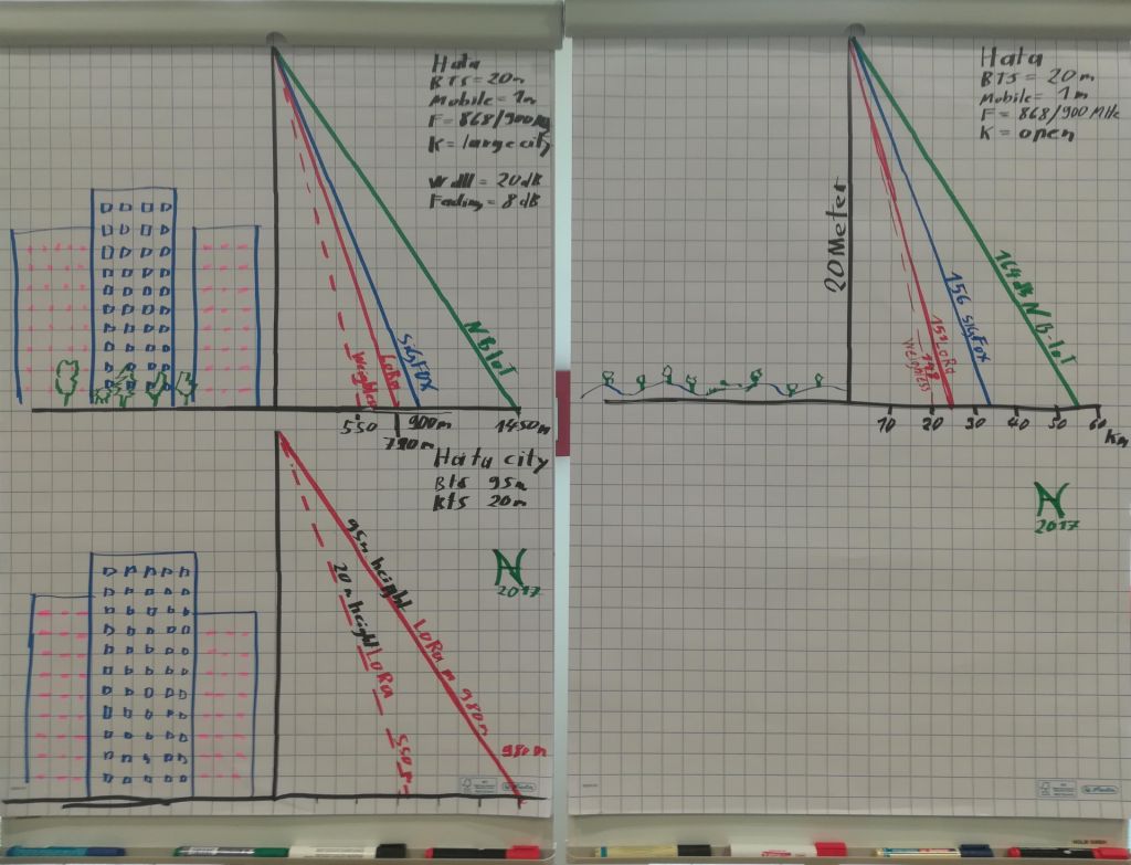
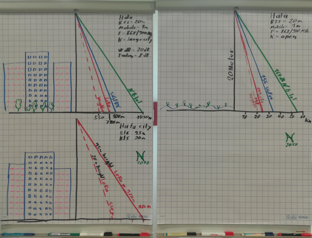
Example of an Okumura-Hata radio propagation at LPWAN Congress on 14th of December 2017 in Frankfurt Germany http://www.managementcircle.de/va_microsites/lpwa.html
Values used for the sketches at the photo
Upper left sketch: Upper right sketch:
| Hata properation | Large City | Hata properation | Open |
| BTS antenna height | 20 meter | BTS antenna height | 20 meter |
| Mobile antenna height | 1 meter | Mobile antenna height | 1 meter |
| Frequency unlicensed | 868 MHz | Frequency unlicensed | 868 MHz |
| Frequency licensed | 900 MHz | Frequency licensed | 900 MHz |
| Weightless 600 bps LB | 148 dB | Weightless 600 bps LB | 148 dB |
| LoRaWAN 300 bps LB | 151 dB | LoRaWAN 300 bps LB | 151 dB |
| LoRaWAN 625 bps LB | 148 dB | LoRaWAN 625 bps LB | 148 dB |
| SIGFOX LB | 156 dB | SIGFOX LB | 156 dB |
| NB-IoT 100 bps LB | 164 dB | NB-IoT 100 bps LB | 164 dB |
| NB-IoT 6000 bps LB | 154 dB | NB-IoT 6000 bps LB | 154 dB |
Lower left sketch:
| Hata properation | Large City | ||
| BTS antenna height | 20 meter | ||
| Mobile antenna height | 1 meter | ||
| Frequency unlicensed | 868 MHz | ||
| Frequency licensed | 900 MHz | ||
| Weightless 600 bps LB | 148 dB | ||
| LoRaWAN 300 bps LB | 151 dB | ||
| LoRaWAN 625 bps LB | 148 dB | ||
| SIGFOX LB | 156 dB | ||
| NB-IoT 100 bps LB | 164 dB | ||
| NB-IoT 6000 bps LB | 154 dB |
The upper right sketch shows the range of different LPWAN technologies in open terrain ranging from 21 to 34 kilometres depending on the link budget and the frequency used. In the left sketch those impressive 21 to 34 kilometres shrinks down to just 550 to 1450 metres in the city. The link budget, the frequencies and the height of the antennas remain constant. The only changed value is “K” in the Okumura-Hata propagation model and a penetration loss of 28 dB. “K” was changed from “open” to “large city”. By the way, if you use “K” for “small city” then the attention is virtually the same. Before we used the Okumura-Hata propagation, we reduced the link budget by 20dB for wall penetration and 8dB for fading. The second sketch on the left shows two radio links with a link budget of 148dB (Weightless/LoRaWAN) but a different height for the base station antenna. The change from 20 metres to 95 metres in the height of the base station antenna only increased the coverage range from 550 to 980 metres. This is an important commercial consideration.
The rental fee to place a transmitter on a 20 metre high building in Hanover, Germany, for example, is Euro 300 per month. On a 95m high building, you will need to pay 3000 Euro per month – ten times more! Be aware that a private LPWAN with indoor coverage on unlicensed frequencies is not free of charge! You have to factor in between 300 Euro and 3000 Euro for the rental fee on the roof of the building. You can research height specific rental fees yourself – hello Google.
NB-IoT is planned to provide Coverage Level (CL) 1. CL 1 equates to a link budget of 154dB or better. The 154dB link budget of NB-IoT is close to the 156dB CL for SIGFOX and means that we can use this for radio propagation calculations for NB-IoT.
The link budget for NB-IoT and SIGFOX includes the gain of the base station antennas. The link budget for Weightless and LoRaWAN is calculated without the gain at base station antenna. Any gain will reduce the beam angle and, worst case, high gain antennas with small beam angles will result in problems in your LPWAN. Emergency vehicles in Germany in hilly regions use zero gain antennas at the vehicle and at the base station; they know why and it makes sense to learn from them. However, it is up to you to add link budget to your Weightless or LoRaWAN base station through greater antenna gain and smaller antenna beam angle if your use case can tolerate a narrower beam angle.
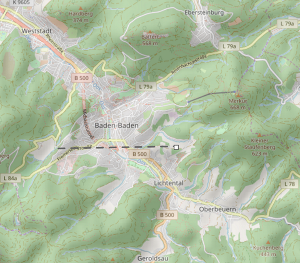
In a recent presentation to municipal authorities during the LPWAN Congress in Frankfurt, I was asked about the signal propagation loss for the radio link between an LPWAN base station on a mountain in Baden-Baden, Germany, to water towers in the city. If you do not know where Baden-Baden is then this might not mean much to you but we are talking about the interface between a base station in a rural area and end devices in a suburban area. For this use case the network planners can use the Okumura-Hata propagation model with a penetration loss of 0 dB, maybe 8 dB for fading, for the rural environment. For the wastewater treatment plant in the suburban environment, they must switch to the Okumura-Hata suburban K values.
At the end of this exercise, they saved the cost of installing underground cables between the water tower and the monitoring centre – about 30,000 Euro per tower. The price of a private LPWAN base station in this context is negligible.
Either a LoRaWAN or Weightless gateway will work but the Weightless base station will do the job better. Weightless, with its TDMA, LBT and frequency hopping is not limited by duty cycle regulations and is able to send acknowledgments in near real time. LoRaWAN is slower and offers no realistic FOTA (Firmware update Over the Air). SIGFOX will charge at least Euro 8 per year for just 12-byte messages and is limited to just four acknowledgments per day. NB-IoT will cost between 2 Euro to 10 Euro per year without limitations in either upload or download. For the few hundred bytes per transmission, NB-IoT is fine.
The city council will also need to cover the costs of maintenance of a private LPWAN base station. This makes commercial sense when additional use cases are added to the initial business case with negligible incremental costs on expansion. Here is an example of how a use case based on an application involving street lights enabled additional value add when smart parking and waste management capabilities were added to the infrastructure with only a modest incremental cost.
Smart city use cases
- Streetlight – assumption for city of Hanover, Germany:http://www.gsm-modem.de/M2M/m2m-componets/internet-of-things-case-study-street-lights/
- Smart parking – assumption for city of Hannover, Germany:http://www.gsm-modem.de/M2M/m2m-apps/iot-case-study-smart-parking/
- Waste management – assumption for city of Hanover, Germany: http://www.gsm-modem.de/M2M/m2m-apps/internet-of-things-case-study-smart-waste-bins/
Summary of the LPWAN planning
- Step one, plan using line of sign and select the locations for your base station antennas
- Step two, use the Okumura-Hata Propagation model in Excel File and draw circles on a map to plan basic coverage
- Step three, use free of charge terrain software for radio propagation modelling
- Step four, place test transmitters and confirm that the signal propagation characteristics meet your needs
- You can analyse radio propagation on 3D terrain software with a 3D environment and make relevant calculations before step four if you have the budget
Has this article piqued your interest? Do you plan to deploy your own private LPWAN? Do you plan to deploy IoT devices with embedded antennas? Do you have an IoT prototype and need to optimise the design or minimise the price? If you have answered YES to any one of these questions then please do not hesitate to drop an email to harald.naumann (at) lte-modem.com and to ask for a proposal or some engineering services to make your IoT idea a cost-effective reality.
Harald this is fantastic, thank you!
Hi Joe, it was a plesure for me.